


14: Lakes of Sammamish: Where to Swim, Fish, Paddle, and Live on the Water
Lake Sammamish, Pine Lake, Beaver Lake, Yellow Lake and a few you can't see from the road: who can use each one, the rules in one line, and what it means if you want to live on the water.
Lakesof Sammamish: Where to Swim, Fish, Paddle, and Live on the Water
The city is named for a lake, but Lake Sammamish is only part of thewater story. Up on the plateau itself there are three smaller lakes,Pine Lake, Beaver Lake, and Yellow Lake, and each has a very differentrelationship with the people around it. Pine Lake has a city park andseasonal lifeguards. Beaver Lake has a lodge and a rack of free loanerlife jackets. Yellow Lake sits inside Klahanie, where access is ahomeowners’ association question.
That’s the real question with Sammamish’s lakes: not which one isprettiest, but who is allowed to use it. Some are public, some areresident-only, and a few are hard to spot from the road. Below is eachlake, its rules in one line, and, at the end, what it means if you wantto live on the water instead of just visiting.
Lake Sammamish
The big one. Lake Sammamish covers roughly 4,850 acres, withSammamish along its eastern shore, Issaquah at the south end, andRedmond and Bellevue to the north and west. Most of the shoreline isprivate, so the handful of public access points matter:
Sammamish Landing (Sammamish). An 8-acre park onthe eastern shore with three small beaches, two docks, a picnic shelter,and a display on the railroad that once ran along today’s East LakeSammamish Trail. It’s the only public property on the lake’s shorelineinside Sammamish city limits.
Lake Sammamish State Park (Issaquah). The lake’ssouth end, and the main public boat launch. It also has swimming beaches(Tibbetts and Sunset), picnic shelters, and athletic fields.
Idylwood Park (Redmond). Public access on thelake’s west shore.
At the north end, Marymoor Park in Redmond is where the 11-mile EastLake Sammamish Trail begins, a flat paved ride or walk along the waterthat comes up again and again in what people love about living here.
For anglers, wild coastal cutthroat, smallmouth bass, and yellowperch are the main draws. Kokanee, the lake’s landlocked sockeye, spawnin creeks like Laughing Jacobs, Tibbetts, and Issaquah Creek, and areclosed to fishing.
The rules, in one line: swim only at designatedbeaches (Sammamish Landing or the state park), launch boats at the statepark (fees apply), and check WDFW’s current rules before fishing, sincekokanee, steelhead, and some salmon are closed.
Pine Lake
Pine Lake is Sammamish’s most neighborhood-scale lake: a small lakewith a city park on its shore and homes around it. Pine Lake Park hassandy beaches, a designated swimming area, and calm water for kayaks andpaddleboards, and it’s a good example of what the plateau’s lake parksdo well. We introduced the Pine Lake neighborhood in 8Sammamish Neighborhoods Worth Knowing.
The rules, in one line: swim only in the designatedarea (lifeguards are on duty only during specific summer weeks), andfishing season runs from the fourth Saturday in April through October31, with a license.
Beaver Lake
Beaver Lake is actually a chain of three lakes, and the main lake iswhere the recreation happens. Beaver Lake Park covers 83 acres, with aswimming area, forested trails, a big meadow, and the historic BeaverLake Lodge, which began as a private resort in the 1930s. In summer thepark lends out life jackets for free, and the lake hosts the swim leg ofthe annual Beaver Lake Triathlon. One quirk: the public boat ramp isn’tin the park, it’s a state Fish & Wildlife access site on the lake’ssoutheast side. We covered the park in more detail in GettingOutside in Sammamish.
The rules, in one line: swim in designated areas,borrow the free life jackets in summer, fish year-round with a license,and use electric motors only, since gas motors aren’t allowed on thelake.
Yellow Lake
Yellow Lake is tucked into Klahanie beside Klahanie Park. It’s small,about 10 acres, and named for its yellow water lilies. A forested buffersurrounds it and a walking trail circles it, so it functions more asurban wildlife habitat than a swimming hole. It’s shallow and edged withlily pads, so don’t picture a beach.
Ownership and access are worth confirming rather than assuming.Reports describe the lake as owned by the Klahanie HOA, and the trail’sstatus isn’t as clear-cut. The Klahanie HOA can tell you what’s open tonon-residents: klahanie.com.
The rules, in one line: treat it as resident-onlyunless the HOA says otherwise, and don’t assume any swimming, fishing,or boating access.
The lakes you’ll hearabout but rarely see
Laughing Jacobs Lake. It’s the source of LaughingJacobs Creek, which runs through Sammamish and Issaquah to LakeSammamish. Below the creek’s falls is a primary spawning ground for thebig lake’s kokanee. The lake itself is reportedly private, so this oneis a story rather than a destination.
Ames Lake. It sits north of the city inunincorporated King County, near Union Hill-Novelty Hill. It shows up onregional maps, but we couldn’t confirm public access details, so ifyou’re house hunting up north, ask about it by address.
Ebright Creek Park. It’s not a lake, but thisneighborhood park has trails and a creek, and it’s a good stop for waterwithout a beach.
If you want to live on thewater
“Lake living” in Sammamish can mean three different things, and theprice, permits, and day-to-day experience differ a lot between them.
True waterfront. The property touches theshoreline, usually with a dock. You’ll find these on Lake Sammamish’seast shore, Pine Lake, and Beaver Lake. Frontage and views command apremium, and docks, lifts, and shoreline improvements add both lifestyleand regulatory complexity. It isn’t unusual to see a Beaver Lake listingwhere the frontage is tied to a shoreline variance.
Deeded or HOA lake access. The home isn’t on thewater, but the owners get access through an easement or acommunity-owned park or beach. Several developments around LakeSammamish own small private parks for residents. This can be the mostaffordable way to have a dock or beach, but the details live in thelegal documents, so read them.
Lake-adjacent. You live near the water and use thepublic parks: Pine Lake Park, Beaver Lake Park, Sammamish Landing, orthe state park. Because most of the shoreline is private, these publicaccess points are the whole story for many households.
Before you buy on or near a lake, ask about:
The dock’s permit history, and whether it’s allowed to stay asis.
The exact wording of any water-access easement or HOA beachrights.
Whether the lot sits in a mapped flood area, and whether floodinsurance will be required.
Shoreline rules that could limit a remodel, addition, or newdock.
The lake’s own rules: Beaver Lake, for example, allows electricmotors only.
Not sure which of the three fits? Tell us how you’d use the water,and we’ll search accordingly.
Helpful links
Cityof Sammamish Parks & Trails, for current hours, lifeguard weeks,and swimming rules
BeaverLake Park & Lodge, including the life jacket program
SammamishLanding Park
WDFW:Lake Sammamish and BeaverLake, for fishing rules and access
Where they sit
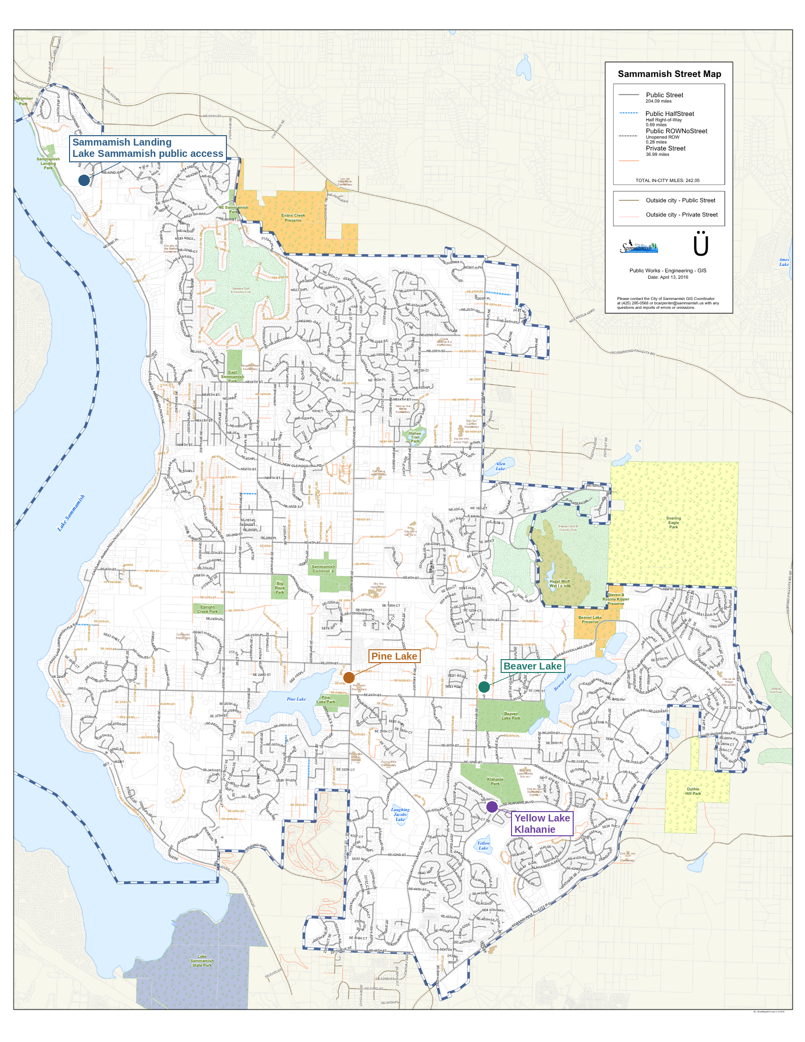
Official City of Sammamish street mapannotated with callouts for Sammamish Landing on Lake Sammamish, PineLake, Beaver Lake, and Yellow Lake in Klahanie
Base map: City of Sammamish Public Works – Engineering – GIS,Sammamish Street Map (April 13, 2016). Callouts and markers added by us,plotted from real coordinates; not an official city product.
This is a supplementary post in our Why Sammamish?series.
Kelly Azzarello Real Estate | Compass 📧 kelly@kellyazzarello.com 📞(425) 830-6457 🌐 kellyazzarello.com

12: The Plateau Was Built on Horseback
Before it was a tech suburb, the Sammamish Plateau was horse country. A personal history, plus today's boarding barns, riding club, and horse-friendly trails.
The Plateau Was Built on Horseback
Before Sammamish was a city with a Costco headquarters four milesaway and a spot on Money magazine’s best-places list, it was chickenfarms, dairy farms, and open land, and for a lot of families who livedhere through the 1970s and 80s, it was horse country. That historyhasn’t disappeared. It’s just gotten quieter, tucked into a handful ofboarding barns, a genuinely dedicated riders’ club, and trails thatstill carry the word “horse” in their rules even as the plateau aroundthem filled in with rooflines.
My stepfather lived here through the 1970s and into the 80s, on aplot of land on the Pine Lake side of what’s now Klahanie. They kepthorses, and rode them under the power lines and across the open landthat’s now the neighborhood’s own Powerline Trail, the same stretchresidents walk, run, and bike today without necessarily knowing what itused to be. A ride usually meant a trip down to Sadlier’s Country Store,near where the Pine Lake QFC sits now, where a hitching post out frontsaw as much use as the parking lot. It’s a detail that’s easy to losetrack of on a plateau that’s grown as fast as this one has: twenty yearsbefore Klahanie was a neighborhood, it was still a place you’d ride ahorse to the store.
A hitching post at the general store
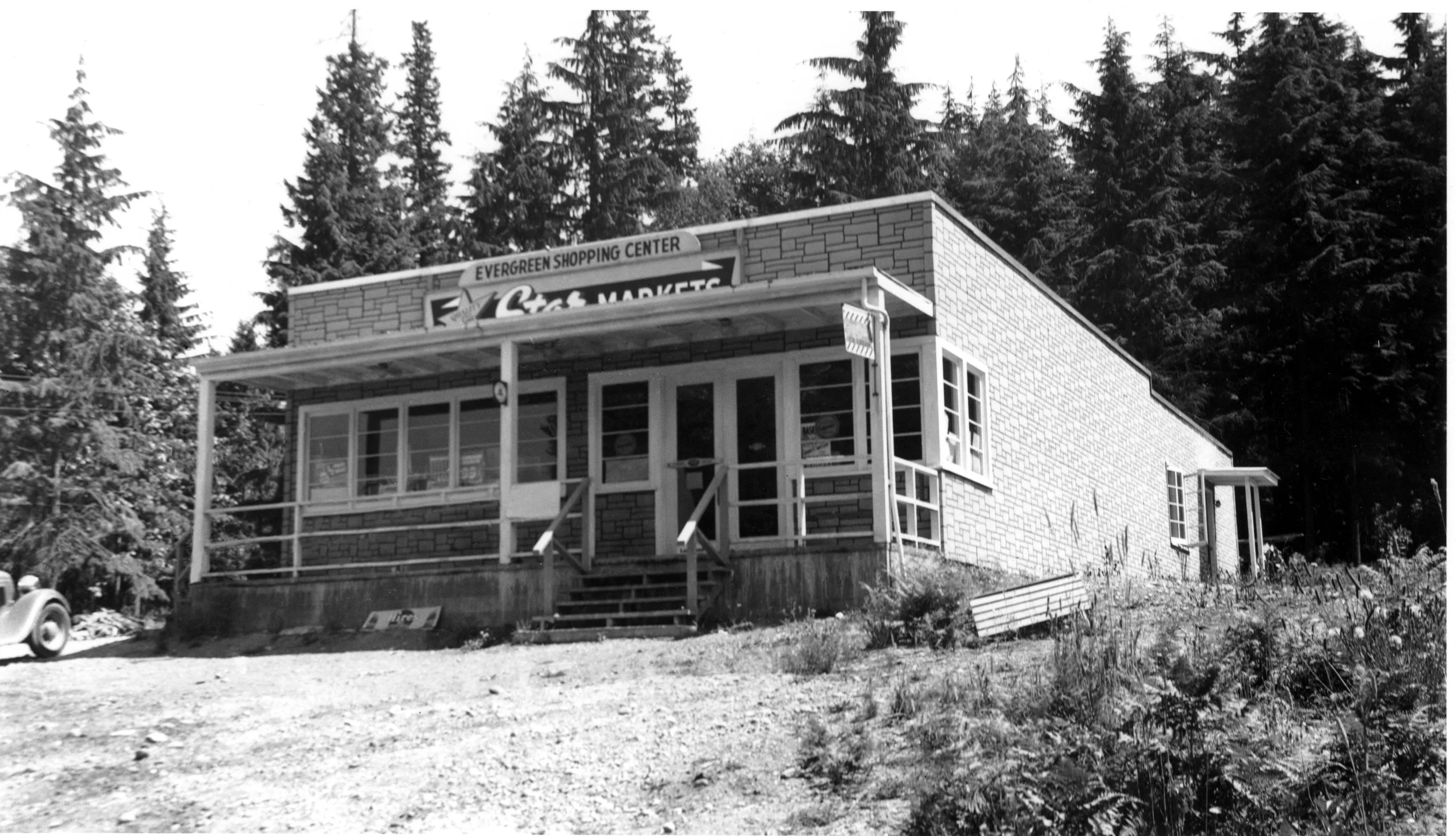
Sadlier’s Market, Pine Lake (Sammamish, WA)
Sadlier’s Country Store, known as Braden’s before that, sat at what’snow 2902 228th Avenue SE, the current address of the Pine Lake QFC (the building itself stood roughly where August Moon Chinese Restaurant istoday). Roy and Arminta Braden built it in 1946 and opened it in 1948;Joe Sadlier bought it around 1968 and the Sadlier name stuck until thestore closed in 1984. It was the only store on the plateau that soldmeat in its later years, which helped it outlast its smaller counterpartacross the lake. And it had a hitching post out front that localsgenuinely used, a detail confirmed independently by a 2011 Seattle Timespiece, in which a resident who arrived on the plateau in 1981specifically remembered horses tied up next to the cars right up untilthe store closed a few years later.
The Sammamish Saddle Club
The plateau’s horse community never fully went away, it organized.The Sammamish Saddle Club has spent years working to keep equestriantrail access intact as development filled in around it, includingreconstructing a trail link that was severed by a new housingdevelopment. The club’s advocacy work runs deeper than trailmaintenance, too: former club vice president Michelle Petitti’s horseadvocacy on the plateau led directly to her serving on the SammamishCity Council, a nice reminder that the horse community here has realcivic weight, not just a hobbyist’s footprint.
Today the club maintains an “adopt-a-trail” relationship with agenuine loop: Soaring Eagle Regional Park connects through the HazelWolf Wetlands (managed by the land trust Forterra) to Beaver Lake Parkand back, a roughly two-hour ride if you’re doing the whole thing onhorseback.
Where to ride and board today
RockMeadow Equestrian Center, on SE 34th Street, isthe plateau’s best-known boarding and training facility: a 10-acreproperty surrounded by more than 100 acres of pasture, wetlands, andtrails, with both an indoor and outdoor arena and ahunter/jumper-focused instruction program for riders from beginnerthrough competitive levels. A handful of other boarding and trainingoperations, including Gold Creek Equestrian Center, Red Gate FarmTraining, and Tashunka (which started in 2002 as a youth horsemanshipand leadership program before growing into full boarding and training),round out the options for anyone looking to keep a horse on the plateautoday.
The trails that still say“horse”
Equestrian use is folded into the plateau’s existing trail systemrather than set apart in its own network. Soaring Eagle RegionalPark carries real equestrian trail access as part of the SaddleClub’s adopted loop. Duthie Hill’s shared multi-usetrails are open to hikers, trail runners, and horses alongside mountainbikers, with horses holding the right of way. It’s a small detail, butit’s a real one: even a mountain bike park built in 2010 was designedwith the plateau’s older horse culture in mind, not around it.
Where things sit
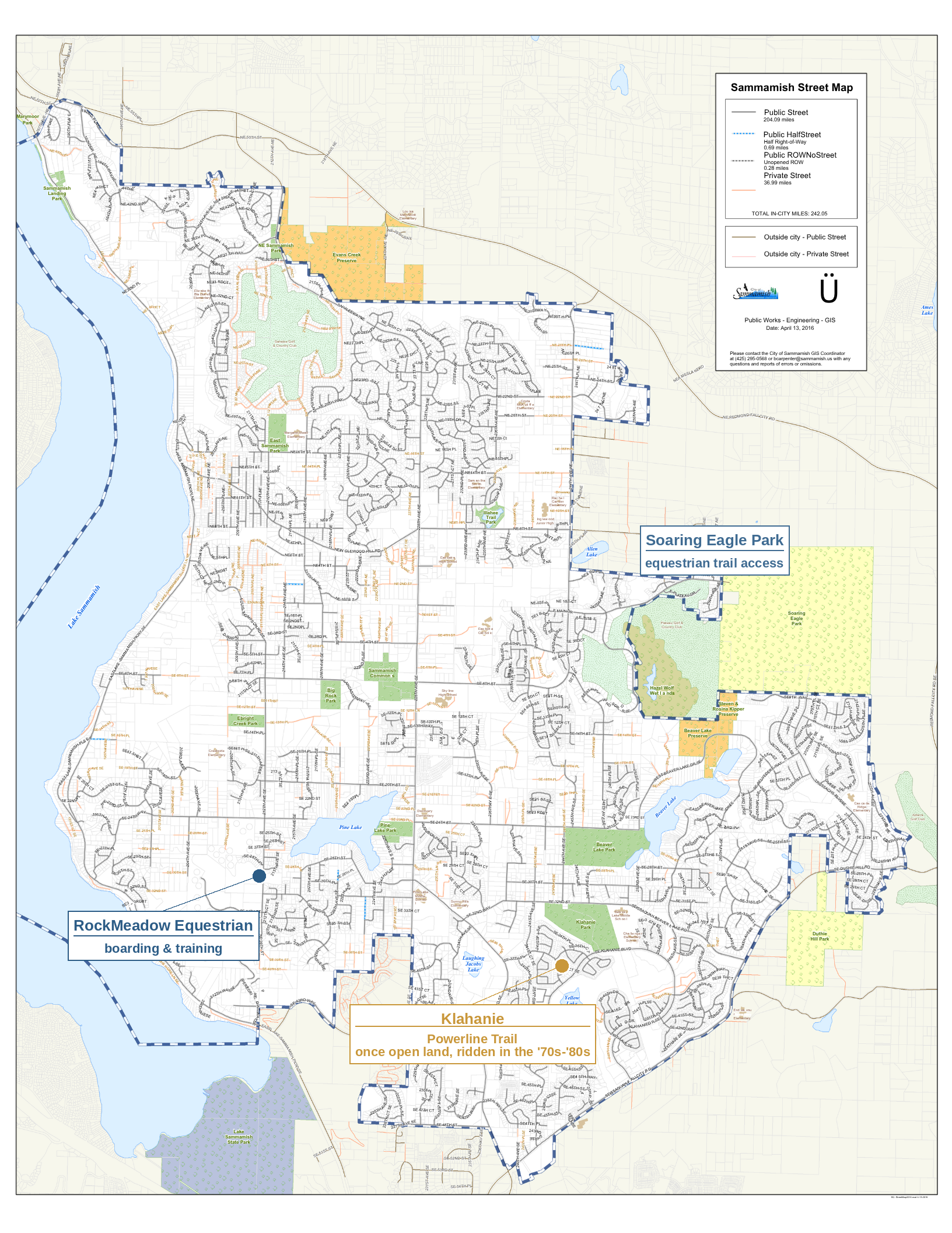
Official City of Sammamish street mapannotated with callouts for Klahanie and the Powerline Trail, RockMeadowEquestrian Center, and Soaring Eagle Park
Base map: City of Sammamish Public Works – Engineering – GIS,Sammamish Street Map (April 13, 2016). Callouts and markers added by us,plotted from real coordinates; not an official city product.
This is a supplementary post in our Why Sammamish? series. We’realso looking into the plateau’s other historic general stores, includingBarker’s Store (Pine View Grocery) on the other side of Pine Lake, for afuture post and companion video in our Then & Now series.
Kelly Azzarello Real Estate | Compass 📧 kelly@kellyazzarello.com 📞(425) 830-6457 🌐 kellyazzarello.com

11: Two More Neighborhoods and Two with Beach Access
Sammamish isn’t one uniform suburb, it’s a collection of genuinely distinct neighborhoods. Here’s an introduction to 8 of them, from the largest (Klahanie) to the most exclusive (Aldarra).
Our original neighborhoods roundup, plus the standalone posts on Klahanie and Trossachs, covered a good cross-section of the plateau, but they leaned toward the south and east. This post fills in three more, spread deliberately across different parts of the city: one right in the middle of the plateau near the high schools, one up north, and a special look at what might be Sammamish’s best-kept-secret amenity: private, residents-only beach and boat dock access to Lake Sammamish itself, which turns out to exist in more than one neighborhood.
Sammamish Highlands: the actual center of the plateau
If Sammamish has a geographic and civic center, it’s here. Sammamish Highlands sits on 228th Avenue right between the city’s two comprehensive high schools, Eastlake to the north and Skyline to the south, and it’s built around the Sammamish Highlands shopping center: Trader Joe’s, Safeway, Metropolitan Market, and a long list of everyday restaurants and services, several of which showed up in our restaurants post. It’s also right next door to Sammamish Commons, so residents get City Hall, the library, the farmers market, and the YMCA within easy reach too.
Homes here are mostly single-family and townhome product built from the 1990s onward, with sidewalks and community spaces that were genuinely planned in, not retrofitted. For buyers who want to walk to groceries, coffee, and a full-service pharmacy, and who want their kids within a short drive of either high school, this is about as central as Sammamish gets.
Heritage Hills: north of Inglewood Hill Road
Head north past Inglewood Hill Road, into the part of the plateau that didn’t really develop until the 1970s and 80s after Sahalee’s golf course opened and 228th Avenue was extended, and you’ll find Heritage Hills. It sits in the same northern cluster as Sahalee and Timberline, feeding into Lake Washington School District schools including Elizabeth Blackwell Elementary.
Heritage Hills has a quieter, more established feel than the newer developments further south, single-level and traditional homes on generously sized, often wooded lots, without the country-club gate of its Sahalee neighbor next door. It’s a good example of the kind of solid, unflashy neighborhood that doesn’t always make “top neighborhoods” lists but consistently draws buyers who’ve done their homework.
Lake Sammamish Beach Access: the private beaches most people don’t know about
Here’s a feature worth its own section. Sammamish’s public shoreline inside city limits is limited to the small Sammamish Landing park, but tucked into two different residential communities are private, deeded beach and dock amenities that most buyers never think to ask about.
Inglewood Beach Club, on the west side of the plateau at the corner of East Lake Sammamish Parkway and Inglewood Hill Road, offers 125 feet of private lake frontage with a sandy beach, a swimming area, a boat launch, and a dock. It’s an optional, paid membership available specifically to property owners within the Inglewood plat, and it functions as the genuine social heart of that part of the neighborhood: summer picnics, a Fourth of July celebration, and a beach that, on a hot July afternoon, feels like a private lake house shared among a few hundred families instead of one.
Waverly Hills, on the southeast side of the lake near East Lake Sammamish Parkway SE, is a separate neighborhood built around its own private beach club: 106 homes share 400 feet of waterfront, with a sandy beach, swim area, dock, boat launch, and BBQ area. It’s a smaller, tighter-knit community than Inglewood, but the amenity itself is just as real, lake access that comes with the deed rather than a trip to a state park.
Both are genuinely rare things to offer buyers: private, residents-only lake access with an actual dock and boat launch, not just a view. It’s the kind of amenity that’s easy to undersell if you don’t know to ask about it, and easy for out-of-area buyers to miss entirely since neither shows up on a standard “best parks” list.
Where they sit
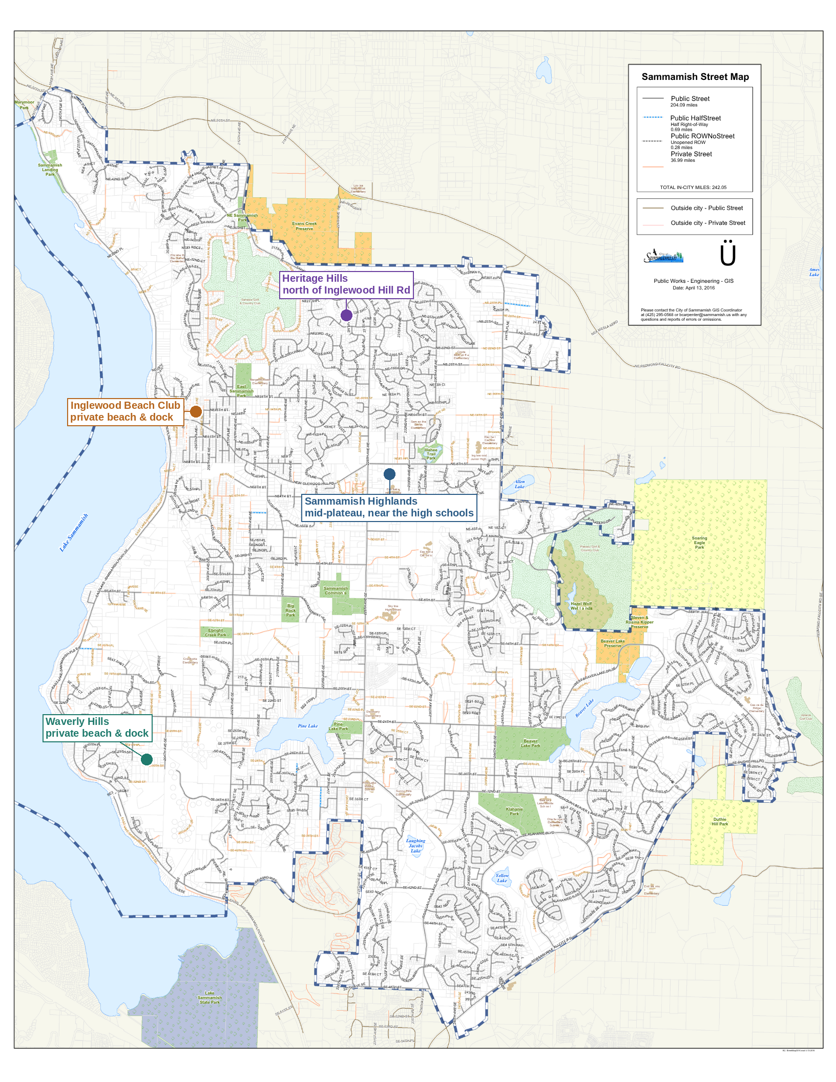
This is a supplementary post in our Why Sammamish? series, expanding on the original neighborhoods roundup. A dedicated post on Sahalee, covering both the residential community and the private golf club, is queued up next.
Kelly Azzarello Real Estate | Compass 📧 kelly@kellyazzarello.com 📞 (425) 830-6457 🌐 kellyazzarello.com

10: Duthie Hill Mountain Bike Park
Duthie Hill isn’t a neighborhood park with a bike rack, it’s a genuinely world-class, purpose-built mountain bike park. Here’s what’s actually there, who can ride, and how to get in.
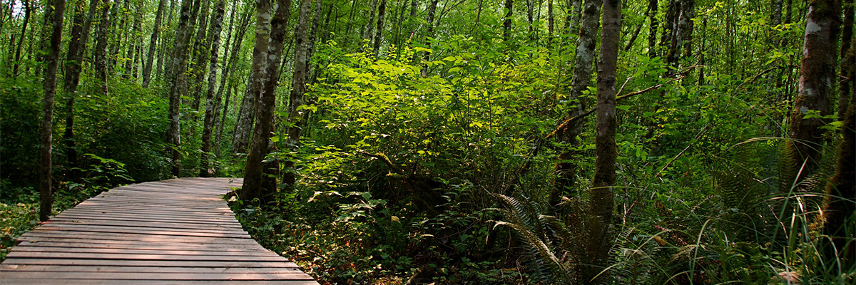
Duthie Hill Mountain Bike Park - King County Parks
A Plateau Amenity Worth Knowing
We’ve mentioned Duthie Hill a few times already in this series, in the outdoor life post and again in the Trossachs neighborhood spotlight, and it deserves its own closer look. This isn’t a neighborhood park with a bike rack. It’s a genuinely world-class, purpose-built mountain bike park that draws riders from across the region, and it sits close enough to Sammamish’s southeastern edge that it functions as a real amenity for the plateau even though it’s technically just outside city limits.
What’s actually there
Duthie Hill covers 120 acres of dense evergreen forest, Douglas fir and western hemlock, with well-draining soils that keep it rideable close to year-round. The trail layout is distinctive: a six-mile network of rolling singletrack forms a four-leaf clover shape around a 2.5-acre central clearing. That clearing is the social hub of the park, with informational kiosks, skill-building features, a picnic shelter, and an engraved donor bench.
Inside each of the four “cloverleaf” lobes, riders find downhill-only freeride trails loaded with berms, jumps, and drop-offs, each lobe has its own character and difficulty range. The outer, cross-country style trails ring the whole park and are shared, one-way, and open to hikers and trail runners as well as bikers.
[PHOTO PLACEHOLDER: a jump line or berm feature, to show the freeride side of the park]
Trail breakdown
A few of the named trails riders navigate by, with approximate length and difficulty:
• Braveheart — advanced, 0.39 miles. The only advanced-rated cross-country trail at Duthie, mostly fast and flowy with a rock garden entrance and an off-camber root roll that bumps up the difficulty.
• Step It Up — intermediate, 1.3 miles. One of the longer cross-country style trails, fast and flowy with optional skinnies and log rides along the way.
• Movin’ On — intermediate, 0.83 miles. More technical than Step It Up, with tight turns, ladders, bridges, and skinnies throughout, a good training trail.
• Ryans — intermediate, 0.29 miles. Short, fun, and flowy.
• The Great Space Coaster — advanced, a feature-rich trail branching off “Bootcamp” with North Shore-style ladder bridges and skinnies, a real test of balance.
Beyond the park boundary itself, Grand Ridge Park connects directly to the south with its own popular cross-country riding, and the trails at Soaring Eagle Regional Park are accessible less than 2 miles to the north.
[PHOTO PLACEHOLDER: a technical feature like a skinny, ladder bridge, or log ride from the central clearing skills area]
Who built it, and who takes care of it
Duthie Hill was designed and built by the Evergreen Mountain Bike Alliance in partnership with King County, funded through King County’s Community Partnerships and Grants program along with Youth Sports Facilities grants, roughly $225,000 in private donations, and thousands of hours of volunteer labor. Phase 1 opened in 2010; Phase 2 completed in May 2012. The park now sees an estimated 100,000 rider visits a year, and Evergreen continues to maintain the trails through ongoing volunteer stewardship.
The Evergreen Mountain Bike Festival is held at Duthie every June and draws riders from across the region for a full day of racing, demos, and community events.
Who can ride, and the rules that keep it working
Duthie Hill is genuinely built for every skill level, from kids on push bikes learning to balance in the clearing to expert riders chasing the advanced lines. A few rules worth knowing before a first visit:
• All trails are one-way. Signage at each trailhead marks direction, and the whole system depends on everyone riding the correct way.
• The cross-country and perimeter trails are shared with hikers and trail runners; the downhill freeride trails inside each cloverleaf are bike-only.
• No overnight parking. The lots are day-use only.
• Pack out your trash. Facilities are minimal beyond a single restroom near the main lot.
• Evergreen’s youth and teen dirt camps require full-face helmets for advanced sessions, a good baseline expectation for anyone riding the more technical freeride lines, even outside a formal class.
Evergreen also runs a full slate of classes and camps at Duthie, from beginner-level youth dirt camps (ages 8 to 13) through intermediate and advanced teen and adult sessions, plus skills clinics for riders looking to progress. Scholarships are available for camps based on financial need.
Accessibility and adaptive riding
Worth being upfront about what this is and isn’t: Duthie Hill is natural-surface singletrack throughout, not a paved trail, and it isn’t a standard wheelchair-accessible path the way sections of the Sammamish River Trail or Cedar River Trail are. That said, it’s become a genuine, well-documented destination for adaptive mountain biking, more so than most parks in the region.
Evergreen Mountain Bike Alliance launched an Adaptive Mountain Bike (aMTB) program a few years back in partnership with Outdoors for All, a Seattle-based nonprofit founded in 1979 that provides adaptive outdoor recreation for children and adults with disabilities. Outdoors for All runs a beginner mountain biking series at Duthie Hill specifically, using electric-assist adaptive mountain bikes, handcycles, prone cycles, and recumbent trikes, alongside standard two-wheeled bikes, for riders who are already comfortable on a bike but new to mountain biking. Registration is required and eligibility criteria apply; details are on the Outdoors for All website.
On the trail-building side, Evergreen’s crews have been physically modifying parts of Duthie, widening the Bootcamp trail in particular, using what they call “universal trail design”: removing pinch points and cutting brush wider, without changing the character or difficulty progression of the trail itself, so a broader range of equipment can actually ride it. New connector trails added in recent years also mean riders can get from the parking lot to the central clearing entirely on trail, without using the access road, which matters for anyone for whom the road shoulder isn’t a safe or practical option.
King County Parks has highlighted Duthie Hill directly in its own accessibility materials as a place where adaptive mountain biking is demonstrated in practice, which is a meaningful acknowledgment for a park that started out built purely for traditional two-wheeled riding.
Getting there
The park sits on the Sammamish Plateau at the Issaquah-Fall City Road entrance, with a roughly 74-vehicle parking lot on the north side of the road. King County Metro routes 269 and 554 stop on Issaquah-Pine Lake Road SE nearby, so it’s reachable without a car for riders coming from elsewhere on the plateau. On busy weekends, overflow parking has historically been available at nearby schools, though that’s worth confirming directly with Evergreen or King County before counting on it.
The layout, at a glance
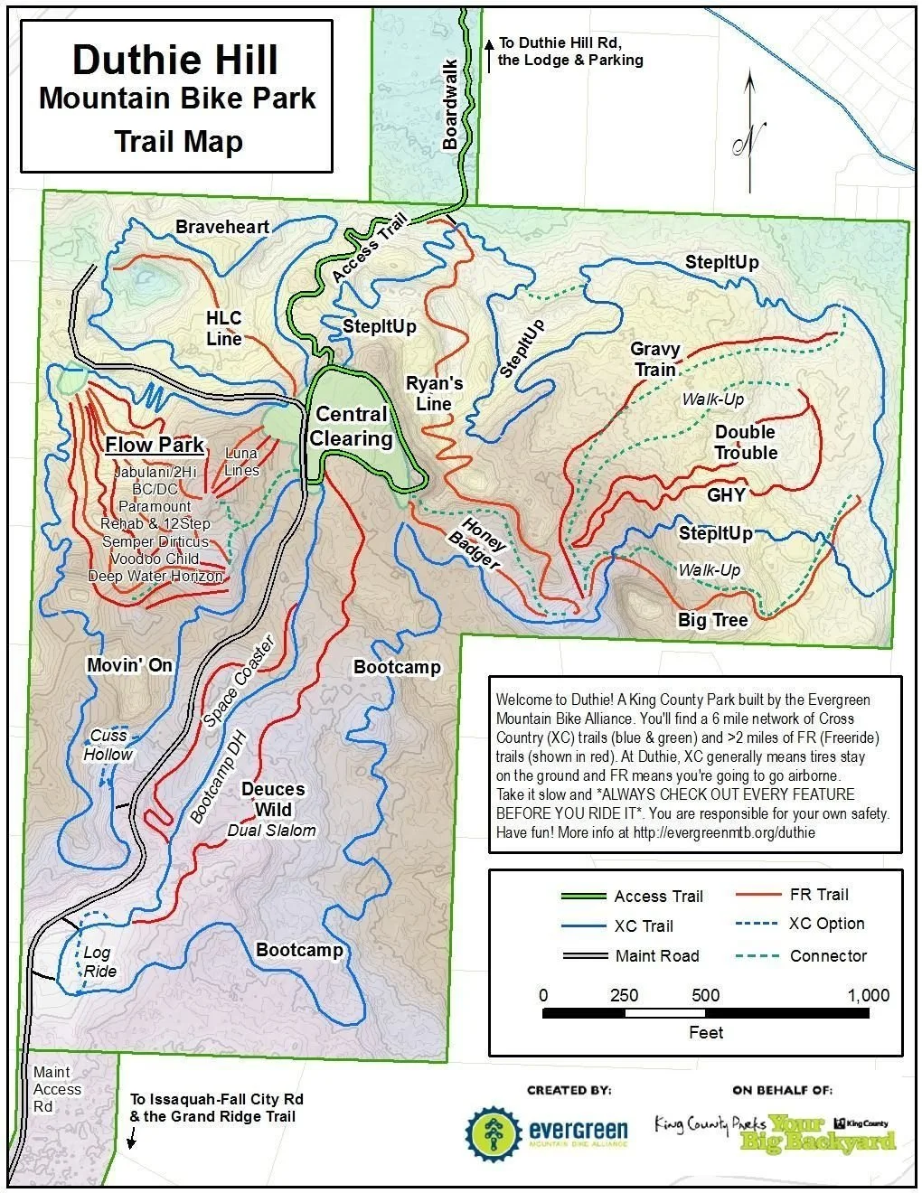
Map courtesy of King County Parks and Evergreen Mountain Bike Alliance.
This is a supplementary post in our Why Sammamish? series, expanding on a landmark first mentioned in our outdoor life post and our Trossachs neighborhood spotlight.
Kelly Azzarello Real Estate | Compass 📧 kelly@kellyazzarello.com 📞 (425) 830-6457 🌐 kellyazzarello.com